Thanks for joining us at the 2024 TB&TM! This page will be updated for the 2025 MCDITE Annual Meeting soon!
Looking for information about the 2024 International Annual Meeting in Philadelphia?
M-TRAIL
The Maryland Transportation Research and Artificial Intelligence Laboratory (M-TRAIL), affiliated with the Maryland Transportation Institute, has extensive experience in Automated Vehicle (AV) technology development. M-TRAIL boasts an in-house autonomous vehicle equipped with an array of sensors, including lidar, radar, cameras, and GPS, as well as drive-by-wire control platforms, on-board units, and high-reliability industry-grade computers. These components are integrated through sophisticated software platforms to enable autonomous driving capabilities. Additionally, the vehicle serves as a testbed for various applications, not limited to autonomous driving research, advanced driver-assistance systems (ADAS) development, and cooperative driving autonomy. The M-TRAIL group has also contributed to the development of FHWA CARMA speed harmonization algorithms.

Dr. Xianfeng Terry Yang is an Assistant Professor (Transportation Engineering) in the Department of Civil and Environmental Engineering at the University of Maryland. Before joining Maryland, he was an Assistant Professor at the University of Utah. Dr. Yang’s current research areas include transportation asset monitoring and management, evacuation planning, traffic operations, traffic safety, transportation equity, and transportation planning. He has been the PI or Co-PI of over 30 projects that are sponsored by multiple agencies such as the National Science Foundation (NSF), the US Department of Transportation (USDOT), the Federal Highway Administration (FHWA), Department of Energy (DOE), Maryland Department of Transportation State Highway Administration (MDOT-SHA), and the Utah Department of Transportation (UDOT). He has published over 140 peer-reviewed research articles in journals and conferences. Dr. Yang founded the Maryland Transportation & Artificial Intelligence Laboratory (M-TRAIL). He is a leading expert in integrating machine learning into transportation and he is the recipient of the prestigious NSF CAREER Award in 2021. He is currently the Associate Editor of the ASCE Journal of Urban Planning and Development and IEEE OJ- Intelligent Transportation Systems, and the Handling Editor of TRB Transportation Research Record. He is also the Vice-Chair of the INFORMS JST ITS committee and the Secretary of the ASCE Artificial Intelligence committee.
CATT Lab
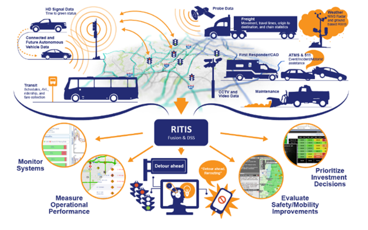
The CATT Laboratory was originally established in 2002 as an academic applied research and development laboratory. The mission of the lab is to support national, state, and local efforts to provide safe and efficient transportation systems through improved operations and management by means of research and development, technology implementation, training, and education. CATT Lab supports national, state, and local efforts to solve important transportation, safety, and security problems. We accomplish our mission by deploying innovative technology and user-centered software and visualization systems. The CATT Lab tour will highlight the Regional Integrated Transportation Information System (RITIS) which fuses data from 40 state DOTs partners and ~17,000 registered users. This tour will feature the RITIS real-time transportation map, probe data analytics, trajectory data analytics, and traffic signal analytics.
Mark Franz earned his BA in Physics and BS in Astronomy from the University of Florida, his MSCE from West Virginia University, and his Ph.D. in Civil and Environmental Engineering from the University of Maryland (UMD) with emphasis on transportation engineering. Currently, Mark is the Lead Transportation Analyst at the Center for Advanced Transportation Technology Laboratory (CATT Lab) at the University of Maryland where he is developing and improving online transportation analysis tools and visualizations for public and private sector clients.
TS&T
Traffic Systems & Technology (TS&T) will be showcasing the following solutions and systems:
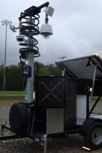
Radar– See everything on the highway up to 1mile. Counts, Classifications, AID, Hard Shoulder Monitoring, Stopped Vehicle Detection, Queue Detection, Wrong Way Drivers, Pedestrian. All weather systems, ideal for Bridge and Tunnel applications too.
Lidar– All weather systems for intersections and roads approaching intersections. Most reliable system to monitor all vehicles, pedestrians. Learn driving habits and walking habits. Counts, Classifications, Speeds, Conflicts between pedestrians and all vehicles types, Red Light running history, pedestrians walking outside the intersection with videos clips, Green Allocation, Phase Interval, Split Trends, Arrival patterns.
ThruGreen Systems– Connecting legacy components to newer technologies. EVP and TSP systems to create time savings and safer and more consistent interactions with signals. Asset Management and work order tracking, Signal timing updates remotely. Live intersection view, place calls and test calls remotely. Connect all cabinets via current network or cell systems.
.

Roger Hale – I have been with TS&T since 2002. Prior to that my previous employment included IT, software, and payroll/HR sales for almost 20 years. I currently oversee all the sales for TS&T and I’m also the lead for the state of Maryland. Since joining TS&T, I have seen TS&T evolve from mainly a pole company to a more solutions-based provider for ITS, lighting and traffic applications. Our knowledge and customer support are paramount in this business as it provides our customers with the tools and confidence, they need to secure jobs and deliver quality materials on time.
I love sports, especially soccer, golf, and football. Occasionally you can find me playing on the poker tables in MD. My wife and I have two amazing boys and our two dogs.
JMT Driving Simulator
JMT Technology Group developed a themed driving simulation for use at a transportation conference. The simulation allowed the user to virtually drive a themed character through a model of Baltimore City while collecting coins to achieve the goal of the game. The fastest times are displayed on a leaderboard to encourage booth visitation and increase engagement.
The simulation immerses you in an experience driving through a digital twin reality mesh of Baltimore using a steering wheel & pedals for the simulator to be as authentic as possible. It uses a reality capture of Baltimore to drive from the Maryland Transit Administration building to the MdQI conference at the Baltimore Convention Center. You drive on real streets within the city of Baltimore.
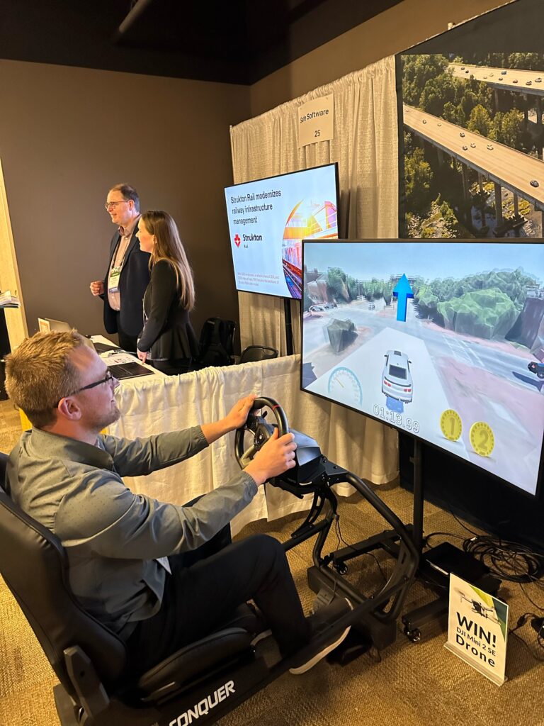
This driving simulator takes reality capture data (such as LiDAR, point clouds, or photogrammetry) and creates interactive visualizations. The simulations aren’t just limited to steering wheel controls, they can be JMT Technology Group’s virtual spaces platform to help create interactive experiences, simulations, and virtual tours that stakeholders can access via the web with keyboard controls or their mobile devices.

Maria Martin is a communications and branding specialist with over 20 years of experience. She has strategically managed all aspects of marketing including writing for technical and non-technical audiences, launching, and supporting websites, strategic print campaigns, public outreach, supporting multiple channels of social media, and managing paid campaigns through Google Ads and social media. She has developed communication strategies for many brands including Whole Foods Market, Hilton, Marriott, Holiday Inn, and the Foundation Fighting Blindness, a national non-profit.